

Walks in the Motueka catchment

There are plenty of lovely walks to do in the Motueka catchment. The MCC encourages residents to get out into their beautiful catchment, to enjoy what our home has to offer. Getting out for a walk is a great way to connect with the water, land and forests. Here’s a couple of ideas to get you out and about.
Hope Saddle Lookout
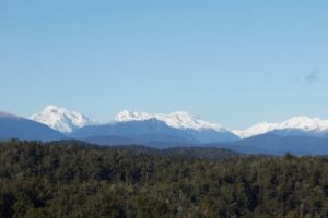
This short, easy walk leads to a viewpoint over highest peaks of Nelson Lakes National Park. It’s at the boundary between the Motueka and Buller catchments.
Time:
10 min return
Distance:
200 meters return
Getting There:
25 km from Kohatu on SH6, the lookout is signposted at the top of the hill.
Track:
The track is evenly formed with a slight incline to the trig marker and lookout.
Notes:
Maori traveled close to the present route of the highway on their journeys between the West Coast/Tai Poutini and Nelson. The Buller River was brimming with eels and a forest full of weka and other food. This was one of the main Ara, or pathways for transportation of greenstone between source and population.
Following discovery of gold at Lyell in the 1860s, a new emphasis was placed on the need to establish a route between the West Coast and Nelson. Dave Clark found this route in 1863, despite the dense forest and steep country. Bureaucratic holdups meant the cart track was only started in the early 1870s.
From the late 1870s the Newman brothers from Spring Grove started a mail run over the saddle, negotiating fallen trees, mud, swollen fords and heavy rains. They also took passengers on the thrilling journey.
Today this a good leg stretcher and stopping off point to let the kids out for a run and toilet stop if driving south.
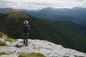
Flora Carpark to Mount Arthur Hut
Gnarled beech forest, ‘Dr Seuss trees’ and panoramic views are all present on this walk in Kahurangi National Park. See https://www.doc.govt.nz/parks-and-recreation/places-to-go/nelson-tasman/places/kahurangi-national-park/things-to-do/huts/mt-arthur-hut/ for more information.
Time:
2h 30 minutes return
Distance:
7.2 km return
Getting There:
Head up the Graham Valley, which becomes a gravel road. As you wind further up, take care. Some sections become narrow and can be rutted and pot-holed. There is a section which has concrete strips because it is steep. Watch for oncoming vehicles and uphill has right of way. It’s doable in a 2WD but you will need good ground clearance. The road ends at Flora Carpark after 10km. There are toilets here and an information board with the track network shown.
Track: The track is well marked and the surface is well graded. However, when it is wet, there are places it can be muddy. Initially, you are following the bulldozed track towards Flora Saddle, but after 10 minutes, take the signposted track to the left towards Mount Arthur and the hut.
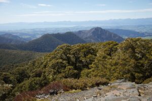
The beech forest here is old and gnarled with a sparse understory. Mosses, lichens and liverworts cover everything. Weka, riflemen and bellbird are numerous in this forest, where intensive predator control has been undertaken by the local community conservation group, Friends of Flora.
At a picnic bench the forest opens up, with the first views out and the appearance of the ‘Dr Seuss Trees’, Dracophyllum traversii, or mountain neinei. The trees become more stunted as the goblin forest finally ends abruptly at the hut (1310m). For the best views follow the track behind the hut for 100m or so and head left up the hill a few metres on the track towards Mount Arthur.
From here the views are 360 degrees, over Tasman Bay to the Richmond Ranges and Kaikoura Ranges, but also the ranges of Kahurangi National Park.
Special Features: Kahurangi National Park is New Zealand’s second largest, covering vast swathes of the north-west corner of the South Island. It has been considered for UNESCO World Heritage status on account of it’s botanical treasure trove and store house of endemic species.
The limestone areas of the Mount Arthur Range conceal the deepest cave system in the Southern Hemisphere. New Zealand cavers have been exploring systems from the Ellis Basin at the top and the Nettlebed system from the bottom, entering via the Pearse Valley. After nearly 50 years of exploration, a dedicated team of elite cavers finally linked the two systems in 2016, affirming what had always been known – a single cave system existed. Spending up to 9 days at a time underground and squeezing through gaps only marginally wider than the human body, the team have photographed the interior, mapping its labyrinths and observing the translucent worms that inhabit the dark depths.
The forest on the way up is a transition from southern beeches, mainly mountain beech and black beech, to the goblin forests associated with the misty realms close to the treeline. A conspicuous feature is the pineapple- topped mountain neinei, whose discarded leaves carpet the forest floor. Trees can live for over 500 years, although you wouldn’t know it, as growth at the extremes here is slow.”